Showing posts with label South Australia. Show all posts

Thursday, 30 August 2018

Road to Penola ...

We left Tantanoola mid morning, in the rain, and drove around the wind farm scenic drive, back through Millicent and headed towards Mount Gambier. Mt Gambier was founded in 1853, and is today a large city. We stopped for lunch and had a drive around Blue Lake. Beautiful. The Blue Lake is a large crater lake located in a dormant volcanic maar. It is one of many crater lakes in the area. One can walk around the crater and the water changes colour with the different light. It is believed to be an average of 72 metres depth.
We drove past some lovely buildings, but no caravan parking and not a lot of time, so “on the list” to come back to. About 50km along the Riddock Highway we came to Greenwise Lake and planned to stay the night, and ended up staying for two. It is just outside of Penola, and is quiet and peaceful, with little highway noise. There are BBQ's and a shelter but no water available and toilets are the other side of the reserve.
Even though it is called a lake, and there are boating rules listed near the 'boat ramp', there is no water in the lake, only sheep grazing. The weather while we were there was English type of weather – grey and drizzling.
On the third day, with the weather clearing, we went for a walk around an old section of Penola, before heading toward Victoria. In 1860, at the age of 18 years, Mary Mackillop - Australia's first saint - moved to Penola and we started our walk at the school Mary Mackillop had built.
We walked down Petticoat Lane – so named because of the number of females born in the lane. It is like walking down a street from the 1850's and 60's. There is even a few houses open to walk around and read the history. The oldest is a two roomed blackwood slab cottage built by Christopher Sharam in 1850. There are stone cottages and a lavender farm. A herb and vegetable garden that is maintained by volunteers and a what will be a beautiful rose garden of hybrid and heritage roses. This street alone is worth stopping to look at.
Yet another place to come back to. Penola is where Saint Mary Mackillop started her first school. Of Scottish descent, Mary was born in 1842 in Melbourne and moved to Penola to be a Governess to her uncle's children in 1860. Her uncle was one of the first settlers in the area, and the town was known as a 'private' town. This is the second town that we have visited this trip that started as a private town. Mary was inspired by priest Father Julian Woods, and she went on to encourage and assist the education of children. She established many schools and helped to established the order of The Sisters of St Joseph, who continued her work. The story of Mary Mackillop is an interesting one. Mary Mackillop died August 8, 1909 and became a Saint in 2010. August 8 is the Feast Day of Saint Mary Mackillop.
 

Sunday, 12 August 2018

The Tantanoola Tiger

In 1893 there were reports of a strange tiger looking animal roaming the area. The reports continued for some years. In 1895 a strange animal was killed and it was discovered it was an Assyrian Wolf. The animal was stuffed and is today on display in the Tantanoola Hotel. This was our next stop and we spent a couple of nights there. The free camp is situated at the railway station and is listed on the South Australian Heritage Register. It is sad to see the vandalism that has taken place at the station – broken windows, burnt floors. The camp has toilets and a dump point. The pub is across the road and is worth a visit for a drink and a meal. The pub is only open some days. The name Tantanoola comes from the aboriginal word tentunola meaning boxwood or camp. Originally part of Mayurra Station, the town developed with the coming of the railway (1876) between Mt Gambier and Adelaide. The town was originally called Lucieton after the then Governor Jervois's daughter Lucy in 1879. Governor Robinson changed the name to Tantanoola in 1888.

Friday, 10 August 2018

The Limestone Coast


Leaving Kingston SE our first stop was the other camp – free – at Pinks Beach. Lovely beach with not as much sea weed, and only a small area for camping behind the dunes. We much preferred the $10 for 48 hours close to Kingston. Next stop was Cape Jaffa. This where the lighthouse in Kingston SE was originally located. Originally named Cape Bernouilli in 1802, I'm not sure when the name was changed. It is a great area for rock lobsters – in season – and a fishing port. Today it is mostly holiday shacks, a caravan park, a few fisherman places and a long long jetty. There are ruins of the old light house cottage, but we couldn't find it. Just outside the village is a new housing development called Cape Jaffa Anchorage.
About 25 km along the coast is Robe. We passed by some wineries and some ruins on the highway before turning towards the coastline and Robe. What a lovely town. We looked for some caravan parking and even had a look at staying at a caravan park for a few days so we could explore. The caravan parks were priced from $38-$45, and the low cost and free camps were not that safe, so we decided not to stay. The town was named after South Australian Governor Frederick Holt Robe, who chose the site in 1846 as a new port. The area was first settled by Europeans in 1839 when Charles Bonney brought cattle from New South Wales to Adelaide. By 1859, Robe had become one of southern Australia's busiest ports. Driving around we saw in the distance a beautiful old house so went to have a closer look, hoping the caravan would be able to get closer. A beautiful large seaside house, named Karatta House, built in the 1850's by pastoralist Henry Jones, it later became the 'holiday' house of many significant figures. One of the first churches was St Mary's Star of the Sea. It was often visited in the early days by Mary MacKillop.
We had a drive around – old buildings, lots of open cafes, and went up to the old goal ruins. Really interesting. There is a heritage walk, but as we couldn't park in or near the town we were unable to do it. The information board at the ruins had a little history, but appeared to be part of a continuing story from the previous boards. It was good to be able to walk around the ruins. The first part of the gaol was built in 1860/61 with a keepers residence and male cells. There were some escapes by prisoners digging through the soft rock, so boiler plates from a shipwreck were used the reinforce the walls. A town well worth visiting, just needs to be more RV friendly.
Further down the coast was Beachport. On the way we saw a brown sign – we turn for brown signs – and came to a Lions lookout over the Woakwine Cutting.
Some very determined men.
Not far away is Beachport, and again the two caravan parks were out of our budget, despite being empty, there were no winter specials to be had. The area was once a whaling port and in 1845 buildings were being constructed. We did see a lot of old buildings, but without a map or info boards – which I'm sure would have been there – we really don't know a lot. However, we are so glad we went in to have look as there is a scenic coastal road, with views that photos don't portray. We couldn't stop at many of the lookouts as we had the caravan. Hopefully we will come back another day. It is obviously a fishing and holiday town.
So off to our overnight camp at old Tantanoola Railway Station.

Thursday, 9 August 2018

Kingston SE – the beach starts here!


A longer drive today of just over 200km, along part of the road we went on the day before and then further around the coast line. We made a wrong turn, but then we got to see the Big Olives. Lovely water views and a couple more pink lakes and a huge rainbow, and an even bigger lobster - to arrive just before 3pm at Kingston SE RV Park. The park is on the coastline, although the waters edge is in the distance. It is very windy with 50km winds reducing overnight. The waves could be seen from the van.
The RV Park is right on the foreshore. There is a build up of weed, which we were told happens every winter, and the waves are hitting the wall of weed very hard. There are toilets located in the park next to the RV Park - a very short walk, and in summer time the seafood shop across the road would be very convenient. There is a credit card machine - tap and go type - and $10 allows one to stay up to 48 hours. A ticket is produced from the machine that you leave on your dashboard, and locals do check. We were the only ones here the first night, but another three vans came the second night. 
We went for a walk up to the information centre, which is in the Council building. A lovely lady there answered our questions about the name - to avoid confusion with other Kingston's in the area SE for south east was added - and what to see. We picked up a historic walking guide and off we went. The buildings have information boards which tell one about the origins of the building, but not always what the building is used for now. This is the old bank house, built in 1876, and opened as the Bank of South Australia. The back appears to be a private residence, and we are not sure if the front rooms are part of the private residence or not.
To have the 'old' photo on the information board and to be able to match up with the 'now' photo was good. This is the site of the old Kingston-Naracoote Railway, and the still remaining Station-master's house c1877. From the photos and the map we could see where the railway went.
The town was established in 1858 by settlers Archibald and James Cooke in order to develop a sea trade town. They built wool stores and shipping offices and encouraged others to help establish the town. The port was declared a safe harbour in 1865. Now it is a holiday destination. Both nights we had a lovely sunset.
We took so many sunset photos.
Kingston must be a wonderful place in the summer. Many of the cafes and restaurants were closed. We did have fish and chips for lunch one day which was lovely, and Peter went to one of the pubs to meet the locals. A place to come back to.

Tuesday, 7 August 2018

Adelaide to Murry Bridge

A short one hour drive from Port Parham, down the Port Wakefield Road to the caravan Park in Adelaide, Windsor Gardens. We passed some interesting sculptures on the side of the road. The Caravan Park is very nice, it is a small park located on the Torrens River. It is about 20 minutes from the centre of town.
We had a drive around the city centre, not much has changed since the last time we came, except the name Polites all over the place. A man born in Port Pirie started with a deli shop in the city and has increased his holdings over the years. He displays his name 'Polites' on all his buildings, which are many. Interesting to know.
The next day Peter went to the caravan show, which was the reason for coming to Adelaide. Me, I did bills (they still have to be paid), some blogging, and sewing – of course. Early next morning we left and headed to Murray Bridge. What a lovely historic place. We drove across the bridge to the Recreation Ground - $10 a night power and water. There were already a few vans there but we found a spot, unhitched and set up for a few days.
We went to the information centre and met Kevin, a most helpful and knowledgeable guide. We got all the relevant history, tourist drives etc. and set off on a drive around the area, following a tourist route – I can't remember the number. Like many country towns, Murray Bridge has many historical buildings. We had a look at the Round House (built 1874), station, and station houses. The wharf area is also interesting. There are paddle boats that do lunch cruises (from $64.90) and an old steam engine. The park at the wharf is great and we can imagine families coming here for weekend picnics. Murry Bridge is located on the Murray River and was the first bridge to be built across the Murray. The first European in the area was Captain Charles Sturt who had rowed a whale boat down the Murrumbidgee late 1829 and reached the Murray River (at what is now Wentworth NSW) in January 1830. He passed by Murray Bridge and continued on to the mouth of the river by February 1830. The river trade started in 1854 and many towns along the river. In 1856 George Edwards and his family were the first settlers in Murray Bridge. Sadly George died a few years later and his wife Mary-Ann set up a place for drovers to rest and have a meal on their way to and from Adelaide. At this time it was called Edwards Crossing. As the port grew and more people came to the area, the village was known as Mobilong Port, from the Aboriginal name 'Moop-pol-thawong' meaning 'haven for birds'. By 1864 a proposal for a bridge was made and by 1879 the bridge was opened and named the Murray Bridge. The town adopted the name in 1924. The bridge became a rail bridge in 1886 and gates were installed to stop walking / horse travellers moving across the bridge when a train was coming. This continued with cars. A dedicated rail bridge was completed along side the original bridge in 1924. The top of the bridge has been raised from the original bridge to allow for todays trucks to pass. Murray Bridge is on the main route from Melbourne to Adelaide.
One of the quirkiest things we have seen for a while was The Bunyip Cave. This attraction is really good. In Dreamtime there was a man who was greedy and catching too many fish. The elders were not happy with his disrespect. The elders became so angry they turned him into a Mulyawonk – half man and half fish – and banished him to the river forever. Children were told never to swim alone and never to catch more fish than you can eat.
We did a full day trip, a loop from Murray Bridge down one side of the river to Wellington where we got a vehicle ferry across to the other side of the river. Ferry services are free in South Australia. Then we took another turning and a ferry to Raukkan. This is an Aboriginal village and has the church on the $50 note. The $50 note also has a photo of David Unaipon. Originally an Aboriginal Mission called Point McLeay, Raukkan – which means 'meeting place' – was the first location where Aboriginal men and women were observed voting in 1896. Located on the banks of the Alexandrina Lake, it is recorded that the Ngarrindjeri people fed explorer Charles Sturt and his party in 1830. A church, school and mission station were built in 1837 and much land was given to the towns people. However the crops didn't grow and by 1916 the South Australian Government supported the town. In 1974 the Ngarrindjeri people took over the running of the town, and in 1982 the town was renamed Raukkan. James Unaipon and his son David lived in the town. James was the first Aboriginal deacon of the church (on $50). His son David went on to be an inventor and writer. David, born in the town in 1872, left school at the age 13 to work with politician and pastoralist, C.B. Young, who encouraged David's academic interests. He invented at least 19 inventions, none of which he gained financially from. He promoted Aboriginal rights, and was the first Aboriginal writer to be published. He died in hospital in Tailem Bend in 1967, at the age of 95 years, and is buried in Raukkan.
We continued on gravel roads down as close to the Murray mouth as we could. Lovely scenery and lots of beach camping. The National Parks in South Australia are called Conservation Parks, and we have already been to many. We wouldn't take a caravan to most, but tents or trailer vans would get in and out ok. While driving along the 4WD track that runs along the inlet behind the dunes that block the Great Southern Ocean we came across the remains of Mark Point Mill. It is really well presented and was a water trough that used an Aboriginal well to pump water into a long trough to feed the stock.

Monday, 6 August 2018

Back on the Road to Adelaide

Leaving our site at Port Vincent, time had come to go, sadly (because we loved our view, and our central location and had so much more to see) we headed north. The first stop was Port Julia, about 10 km up the coast. Another lovely port village with a long jetty and the clearest water.
We then had a look at the low cost camp there - $10 per night or $60 per week. We met the caretaker, a lovely man. He filled us in on all the info. This is on our 'must do' list for another time. Continuing another 10km north into Pine Point, a lovely wharf with great views.
About 30 km along the coast is Parara Point. This is a must see. We went there to see the whale memorial. I'm not sure what I thought it would be, maybe a model of a whale... we didn't know. Wow, so glad we stopped here. A very moving memorial about 7 whales that were beached here in Dec 2014. So very well done.
50m up the road, is a heritage sign that tells the story of the ruins in the paddock next door, and the old farmhouse. The farmhouse was built by Parker Bowman, and the site was chosen because of the availability of water from the Aboriginal wells. Nearby is the ruins of the old schoolhouse and a shepherds house. The info boards are well worth a read. There is also a camp ground, with toilets, just south of the memorial at $10 per day.
Next stop was Ardossan, a lovely little town proclaimed in 1873, with shopping and dining facilities. We thought the South Australian schools had gone back, last Monday, but driving around we did wonder. Today we came across this sign in Ardossan. We had nowhere to park, so we will have to come back.
We have never seen this before. We had to drive around the block to get to the free camp. What a great camp. Only three sites are provided for 2 nights and one must be fully self contained. Each site is its own little parking space and are located right in town, so one can walk to shops, beach, and restaurants. Another 'must do'.
We drove past Port Arthur free camp. Not a bad camp for overnight. Close to the road and road noise, but that's what one gets is staying close to the road. It has never bothered us on our trips. About 35km from Port Arthur, around the top of the Gulf of St Vincent, is Port Parham Campground. Situated right on the Esplanade, and sheltered behind sand dunes. There were quite a few vans already here and most happy campers are off exploring. We parked beside a Jayco van that had two kids seats outside, and thought “Kids – but it's only one night!”, so we parked in the spot next door. Surprise, the happy campers came back and no kids! We have been told in our travels that if one doesn't want others nearby to display a generator or kids toys. So there you go!!! One can feel the heat from the sun, and no wind. Great place to stay. Next time will be longer, much longer! This is a short stay, no more than 14 consecutive days. There are bins, toilets, free bbq's and tables undercover – with lights. The camp is located just behind the dunes, and a very short walk from town and the local sports club that has meals some nights. Adelaide is only a short 72 km away, and our next stop.

Thursday, 2 August 2018

The Copper Coast – Little Cornwall


We continued on to the Copper Coast, so named because of the mining heritage which dates back to 1859. Copper was discovered at Wallaroo near Kadina, and Moonta further down the road. Many Cornish and Welsh miners came to the area, and their influence can still be seen today, especially in local Cornish pasties. Our first overnight was a little town named Alford. Established in 1872 and named after one of South Australia's leading police officers, Henry Alford. The Recreation Park is situated in the grounds of the old primary school (see view from our window above) which closed in 2004. There is one school building remaining due to its historical significance. This building was originally a Strathneath school building, built in 1932 and moved here in 1947. The Alford Primary School was established in 1881 and the huge Pepper Tree has been here since then. In 2004 it was declared a tree of significance. There are toilets, clothes lines, bbq's and a covered picnic area. A great overnight stop. There is not a lot open in Alford. The old pub is closed and has just been purchased. The bowls club was closed when we were there, but does open in the warmer months. There is a cafe type food truck that we were told sells great coffee and lunch. Peter had chat with the lady running in and got the local 'info' – she said she would be open in the morning for Peter's coffee, but sadly she was not – so onto Kadina for Peters coffee.
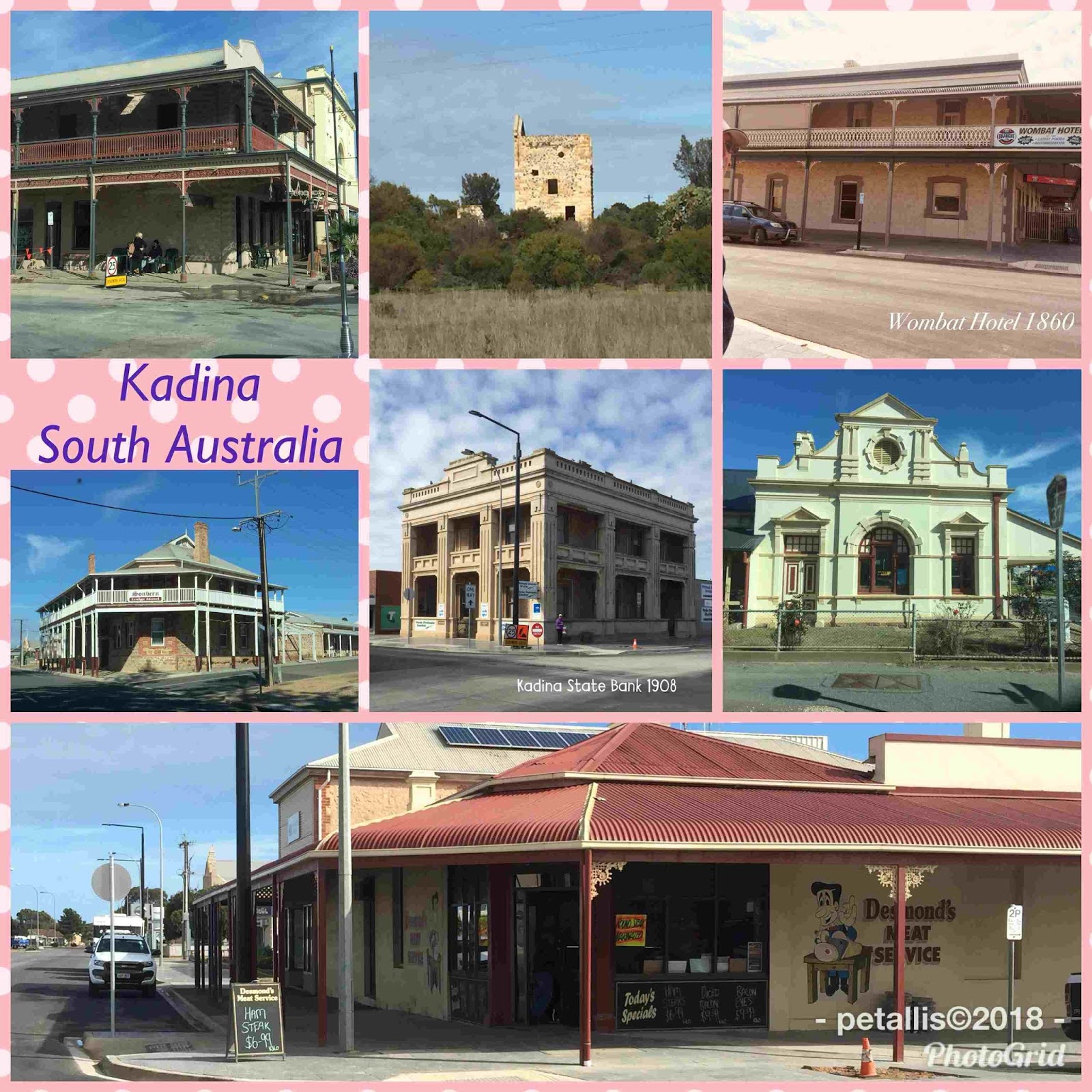
Kadina is named after Kaddy-yeena, an Aboriginal word meaning lizard plain. Many buildings are made of limestone, and there was plenty of parking for caravans. We walked past the first butchers in town, c1870 – and it is still a butchers, and Wombat Hotel c1860, and then Peter found a cafe I continued walking the heritage trail. The first Europeans to the area arrived in the 1830's and the land was used for grazing and wheat. Kadina township was surveyed in 1861 to house the miners who worked in the nearby Wallaroo Mines. Wallaroo – Aboriginal for wallaby urine – is a coastal town with large grain silos, a long jetty and history. In Wallaroo, a shepherd James Boor discovered copper in 1859. It is believed a wombat had dislodged the rock when building his burrow. This is how the Wombat Hotel got its name. In 1860 a smelter was needed. These smelters operated until 1923 and was the largest smelting works in the world outside of Wales. Most of the smelting works have been dismantled, and we suspect town-houses or other coastal accommodation may be going up there. There are still some relics and a lovely short walk from the jetty to the town via a shipping relic trail.
We then drove about 20km to Moonta, and set up in the local recreation grounds for the night. The next morning we went for a walk around the town. Being Sunday we were not hopeful of finding anything open, but we did find a busy coffee shop. It was built in 1863 and was originally a butchers shop. It is so wonderful to see locals caring for their heritage, and in Moonta we saw another example of this. 
In 1870, Moonta was second only to Adelaide in population. I found our future house in Moonta – if we ever win lotto – a beautiful house with shop and sheds.
Moonta comes from the Aboriginal word moontera, meaning thick scrub. The Moonta Mines is a great tourist attraction and during the warmer months has train rides and picnic areas. It was very cold when we were there and the winds were blowing and rain just starting. The museum was the old school and displays the Cornish miners lifestyle as well as much memorabilia from the mining days. Across the road is the old Sweet Shop. In 1861 Paddy Ryan accidentally found traces of copper, a syndicate was formed and by late 1861 Moonta Mining Co. had started operations. Recently the Moonta Mines are has been awarded National Heritage. A few short kilometres away on the coast, Moonta Bay has many historical buildings and a beautiful waterfront.
There are many heritage walks and drives on the Copper Coast – we will be back (when it is warmer).