Leaving the Coral Coast Region and driving into the Gasgoyne Region, there is so much to see around Carnarvon, we decided to stay a week in a caravan park in the town. It was the beginning of June, a Thursday, so peak season for caravaners. There are so many caravan parks in Carnarvon, we phoned four different parks and chose Coral Coast Caravan Park - because it had a deal, pay for 5, stay 7. The caravan parks ranged in price from $33.75 to $46 a night with discount. This park was the closest to the main area of town and had a pool and lovely common area where we saw Marley Wynn perform. We first saw him at Bullara Station. He is really good. Coral Coast Park had great facilities and large sites.
We liked the white crushed shell dust everywhere - made it look so clean and fresh.
Carnarvon is located on the Gascoyne River delta, the river was fast flowing and apparently unusual for this time of year as the river bed is usually very dry. One of the roads over the river was closed due to the high river. The area supplies most of Perth's fruit and vegetables. The original inhabitants were the Aboriginal people and they named it Kuwinywardu, meaning neck of water.
First stop after setting up the van was the information centre. This is also where the weekend markets are.
We discovered that there was still
a lot closed. - The Rocky pool – part of the longest river in Western
Australia – was closed due to flooding.
- Mt Augustus National Park
which was to be our next stop had walks closed – due to flooding.
We wanted to see the worlds largest rock – Burringurrah – at 8 km
long, it is twice the size of Uluru.
- and many beach tracks and minor roads were closed due to flooding.
The first full day there we did the 'fruit loop' drive, starting at the big banana - not really that big.
There are many
farms producing a variety of fruit and vegetables including avocados,
capsicum, grapes. mangoes, melons, tomatoes, around Carnarvon. We were surprised to see the Bibbawarra Road across the Gasgoyne River was open and safe to cross.
We crossed the river and detoured left to see if we could find the track to the other side of the headland and One Tree Point Reserve, we couldn't. The track dwindled down to overgrown areas with no visible sign of any tracks, so we retraced our steps back past all the farms to join the fruit loop again.
The big Humpty Dumpty is located outside what use to be an egg farm. A good place to get a photo.
There were a couple of places to get preserves and fresh fruit, some had limited cafe facilities. Getting back on the highway and turning right along the second part of the fruit loop we came to the Cactus Garden. Started as a hobby 15 years ago by Robert Westcott whose father got him interested as a child. He started by planting cactus at the front of his house for others to enjoy. Now there are over 30 plants, some over 5m tall.
It even has dinosaur bones!A little further down the road was a fruit and vege stall, so we stocked up on some.
We then went down to the fishing port to get some prawns - no where to get them! So we had fish and
chips at Fascine Cafe – not bad fish, chips were just ok, price was good at $15.50. The Fascine is the
name given to the water front. Fascine means bundle of sticks and
represents the early planing of trees along the water front to stop the erosion.
The next day, Saturday, we went to the markets at the Civic Centre. We were hoping to get some more fruit and veges, and there were some but the prices were much higher than the road side stalls on the fruit loop trail.
There were a few crafts and preserves stalls.We left the markets a little disappointed, we were hoping to get some nice fruit for lunch. We headed to the heritage area on Babbage Island. First we drove on a sandy track known as Silver City Road heading to Dwyers Leap. The road originally lead to the meat works, built in 1920, although the buildings were never used for meat. Drought lead to the factory never being used for its purpose. Instead the buildings were used by the fishing industry. During the 1930's and the depression, many homeless families lived here at the meatworks. It was also home to many shearers during the great shearers strike. It is believed the road was called Silver City due to the number of tin sheds erected around the abandoned meat works. Built of handmade bricks by about 40-50 people, all that remains now is the concrete slab. I couldn't find any information about the naming of Dwyers Leap. It is located at the mouth of the Gasgoyne River.
We then backtracked and turned along another sandy track heading towards the beach. We came across old railway tracks and railway cars just left to rot.
There was too much water and we couldn't get to the beach this way so it was back to the main road and One Mile Jetty. The jetty is closed after cyclone damage and one can no longer walk along it. The first European in the area was British explorer Lieutenant Grey aboard the whaling ship The Russell in 1839. He landed on the mainland to explore. It was Grey who named the Gascoyne River after his friend Captain Gasgoyne. He noted that the area was good for agriculture. It was not until 1876 that the first European settlers with sheep established a station. The area grew and so did the need for a port. By 1897 the jetty had been built and wool and livestock were exported. The wool was transported by camel to the port, and Carnarvon was the first port in Western Australia to load and transport livestock to markets. Today the jetty is blocked off with a large board/wall covered in posters.
The Heritage Precinct includes:
- Kimberley Steam Train museum, the last steam train to operate in the North West.
- Shearing Hall of Fame, the first in Western Australia, tells the history of the Gascoyne shearing industry and the shearers strike.
- Light House Keepers Cottage, built around 1900 and was used up until 1970's.
- One Mile Jetty Interpretive Centre - displays of HMAS Sydney II and HSK Kormoron, a famous battle of the coast in 1941.
The Boulton and Paul Helix pump located at the lighthouse keepers house.
This is the top of the old light house, now on display near the lighthouse keepers house
There is a 2.5km walking trail that runs along the old railway track from the Civic Centre in town. Along the Fascine is a cairn commemorating the battle between HMAS Sydney and German ship Kormoran. The battle took place on 19 November 1941 off the Western Australian coast.
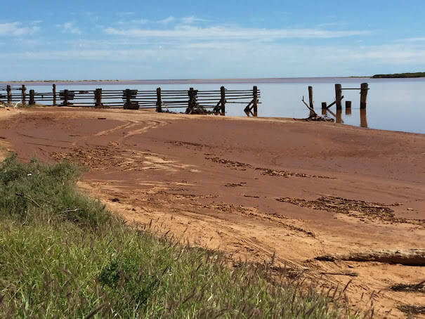
Leaving the heritage precinct and heading towards Pelican Point we detoured down Binning Road to a seafood factory, which was closed. WikiCamps listed an old jetty behind the factory and there is a dirt track that goes around to the beach and the old jetty.
Somewhere on the island was a whaling processing factory, maybe it was here? Carnavon is a lovely town, interesting murals and sculptures. Many old buildings have been repurposed into cafes and shops. So that was the first half of our week in Carnarvon. The rest of the week and our day trip to the Quobba Blowhole next blog.


No comments:
Post a Comment